Geographical definition of Central Europe
For hundreds of years, the Czech Lands and Czechoslovakia in the 20th century were regarded as lands in Central Europe. However, Central Europe is a term variously perceived: geographical, geopolitical or reflecting the regional identities and mental images of the population. From the geographical perspective, Central Europe is defined by the Baltic Sea from Scandinavia in the north and by the Alps from the Italian Peninsula in the south. The western and eastern borders are not completely stabilized and can change according to the experts' various opinions.
References
Hloušek, V.: Pojem střední Evropy, jeho proměny a milníky politického vývoje. In: Sborník prací Filozofické fakulty Brněnské univerzity C 54, Brno 2007, s. 25‒39;
Nováček, A.: Střední Evropa a území Československa mezi Západem a Východem, Geografické rozhledy 28/1, (1918‒1919), s. 4‒7;
Semotanová, E. Zudová-Lešková, Z. ‒ Močičková, J. Cajthaml, J. ‒ Seemann, P. ‒ Bláha J. D. a kol.: Český historický atlas. Kapitoly z dějin 20. století. Praha 2019.

This work is licensed under a Creative Commons BY-NC-ND 4.0
Definition of Central Europe at the beginning of the 20th century
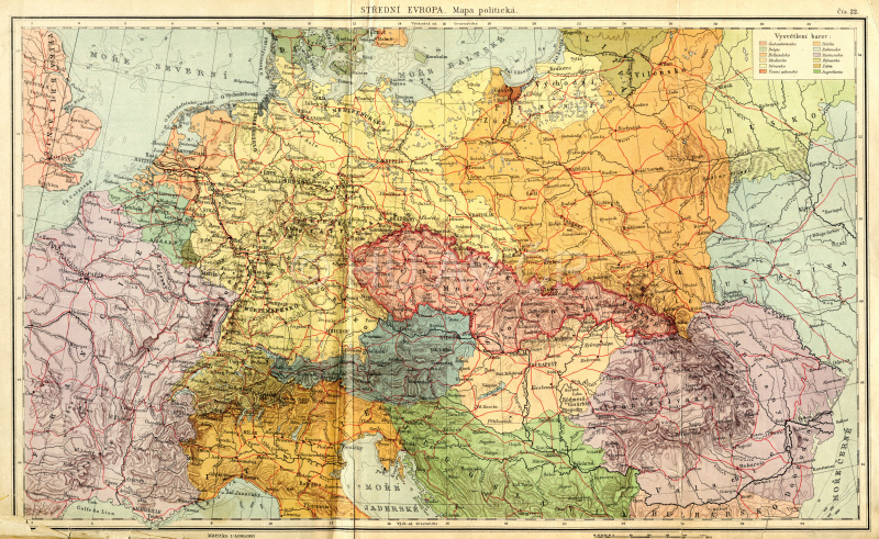
The geopolitical definition is far more variable. It has been discussed not only by the geographers but also by politicians, historians, publicists or writers motivated by ideologies of certain ruling or expansionary groups, notions of an ideal arrangement of Europe or by economic interests. Such definitions are very hard to express in cartography. They are usually not exactly formulated by the authors and do not contain a full list of countries that fall into their ideas. The opinion of Friedrich Naumann was chosen for the early 20th century

Map of Central Europe from 1922, private collection of Eva Semotanová Display map
References
Kárník, Z.: T. G. Masaryk a Friedrich Naumann ‒ dva koncepty pro Evropu. In: AUC, Studia territorialia III, Univerzita Karlova, Praha 2001, s. 93‒115;
Semotanová, E. Zudová-Lešková, Z. ‒ Močičková, J. Cajthaml, J. ‒ Seemann, P. ‒ Bláha J. D. a kol.: Český historický atlas. Kapitoly z dějin 20. století. Praha 2019.

This work is licensed under a Creative Commons BY-NC-ND 4.0
Definition of Central Europe between the two world wars
The geopolitical definition is far more variable. It has been discussed not only by the geographers but also by politicians, historians, publicists or writers motivated by ideologies of certain ruling or expansionary groups, notions of an ideal arrangement of Europe or by economic interests. Such definitions are very hard to express in cartography. They are usually not exactly formulated by the authors and do not contain a full list of countries that fall into their ideas. After the First World War, for example, the politician, philosopher and president of Czechoslovakia Tomáš Garrigue Masaryk proposed a new arrangement of Europe.
References
Masaryk, T. G.: Nová Evropa: stanovisko slovanské. Praha 1920;
Semotanová, E. Zudová-Lešková, Z. ‒ Močičková, J. Cajthaml, J. ‒ Seemann, P. ‒ Bláha J. D. a kol.: Český historický atlas. Kapitoly z dějin 20. století. Praha 2019.

This work is licensed under a Creative Commons BY-NC-ND 4.0
Definition of Central Europe after 1943
The term Danube Federation (Donauföderation) refers to political concepts of unification of a part of Europe within the Danube states. One of the best-known concepts is a proposition by Otto von Habsburg and Winston Churchill from 1943 ‒ 1945 regarding the post-war arrangement of this region. In the mid-20th century, the Polish historian Oskar Halecki perceived Central Europe as a transition zone between the West and the East. In the early 1980s, the writer Milan Kundera considered the position of Central Europe tragic due to the loss of its political and cultural importance.
References
Křen, J.: Dvě století střední Evropy. Praha 2005;
Havelka, M. ‒ Cabada, L.: Západní, východní a střední Evropa jako kulturní a politické pojmy. Plzeň 2000;
Semotanová, E. Zudová-Lešková, Z. ‒ Močičková, J. Cajthaml, J. ‒ Seemann, P. ‒ Bláha J. D. a kol.: Český historický atlas. Kapitoly z dějin 20. století. Praha 2019.

This work is licensed under a Creative Commons BY-NC-ND 4.0
Definition of Central Europe at the end of the 20th century
The term Danube Federation (Donauföderation) refers to political concepts of unification of a part of Europe within the Danube states. One of the best-known concepts is a proposition by Otto von Habsburg and Winston Churchill from 1943 ‒ 1945 regarding the post-war arrangement of this region. In the mid-20th century, the Polish historian Oskar Halecki perceived Central Europe as a transition zone between the West and the East. In the early 1980s, the writer Milan Kundera considered the position of Central Europe tragic due to the loss of its political and cultural importance.
References
Křen, J.: Dvě století střední Evropy. Praha 2005;
Havelka, M. ‒ Cabada, L.: Západní, východní a střední Evropa jako kulturní a politické pojmy. Plzeň 2000;
Semotanová, E. Zudová-Lešková, Z. ‒ Močičková, J. Cajthaml, J. ‒ Seemann, P. ‒ Bláha J. D. a kol.: Český historický atlas. Kapitoly z dějin 20. století. Praha 2019.

This work is licensed under a Creative Commons BY-NC-ND 4.0
Definition of Central Europe in the early 21st century
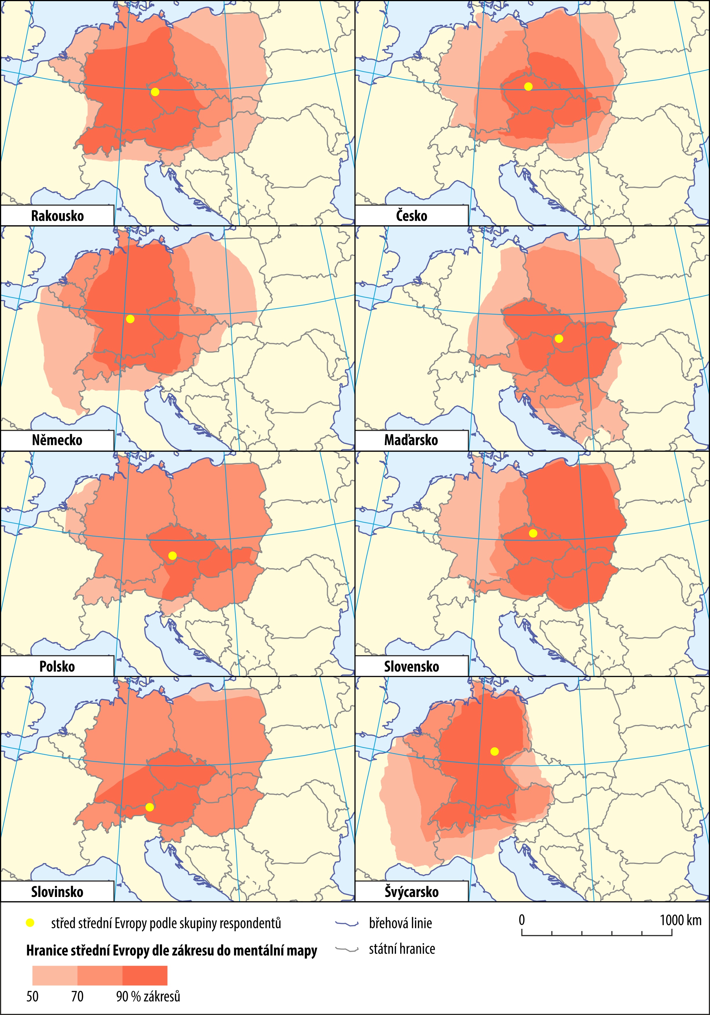
Perception of a region at the time of its creation and identification by the actual nations living in the respective geographical space plays an important role. The degree of identification with an inhabited region can be detected in various ways, for example by using mental maps of the individual nations' populations. The map presents an aggregate result of a survey involving 513 respondents of a comparable social status from eight countries of the Central European region. Attitudes of respondents from the individual countries suggest that the concept of Central Europe is not stabilized and that the respondents tend to locate 'their' country to the centre of Central Europe. The resulting plot shows that the Czech Lands and Austria are currently perceived as typical Central Europe.

Borders of Central Europe as perceived by participants in the inquiry from the individual states. Produced by Jan D. Bláha, 2016, 2020.
References
Nováček, A.: Dualita Evropy: historickogeografická analýza. Praha 2012;
Nováček, A.: Střední Evropa jako „rakousko-uherské“ dědictví, Geografické rozhledy 23 (5), 2014, s. 2–4;
Bláha, J. D. – Nováček, A.: How Central Europe is Perceived and Delimited, Mitteilungen der Österreichischen Geographischen Gesellschaft 158, 2016, s. 193–214.;
Semotanová, E. – Zudová-Lešková, Z. ‒ Močičková, J. – Cajthaml, J. ‒ Seemann, P. ‒ Bláha, J. D. a kol.: Český historický atlas. Kapitoly z dějin 20. století. Praha 2019.

This work is licensed under a Creative Commons BY-NC-ND 4.0
Czech State and Europe in the 20th Century
To some extent, the position of the Czech Lands in Central Europe predetermined the ensuing geopolitical processes. Yet the Czech Lands were frequently important crossroads of political interests and conflicts. For Czechoslovakia, Poland and Hungary, the disintegration of Austria-Hungary and emergence of the successor states at the end of World War I symbolized fulfilment of their effort to gain independence. Simultaneously, however, the post-war arrangement of the world and Europe concealed many risks that culminated in another war (1939 ‒ 1945) and division of the continent into new political interest zones after 1945 and again at the end of the 1980s. Central Europe has always been a space where the West met the East and where the European as well as non-European structures desired to include some of the Central European countries into their power blocks. The geopolitical aspects formed and still form mutual relations between the European states where the Czech Lands still present a sensitive deciding factor in international stability.
Eva Semotanová
Subchapters:

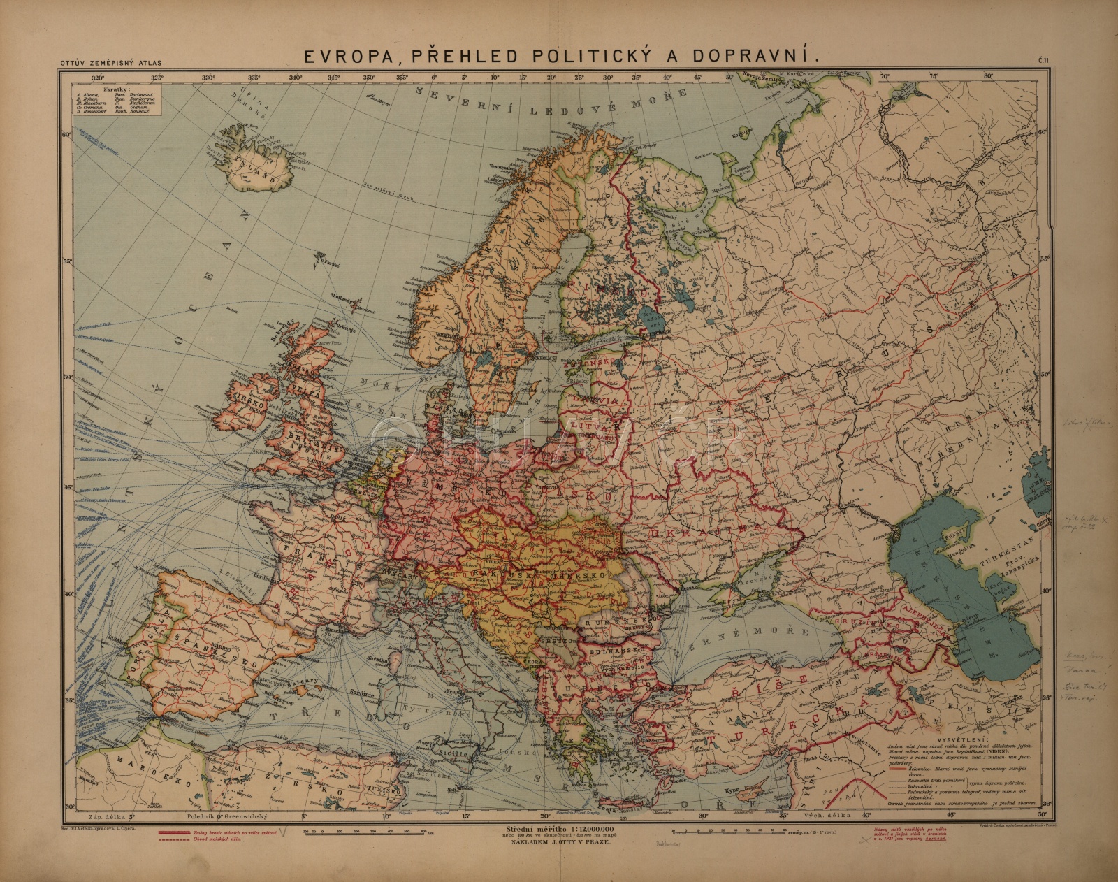
Political map of Europe from Otto's geographical atlas from 1924. The basemap dates from the period before 1918. The names of the states after 1918 (and after the Versailles Conference 1919-1920) are inscribed in red, even with the borders. Map Collection of the Institute of History, CAS. Map display
Authors
historians: Eva Semotanová, Tomáš Burda, Jan D. Bláha
cartographers: Jiří Krejčí, Jan D. Bláha, Pavel Seemann, Zuzana Vaňková
digital atlas: Tomáš Janata, Petra Jílková, Jiří Krejčí, Jitka Močičková, Eva Semotanová, Růžena Zimová
team of authors
References
Semotanová, E.: Historická geografie českých zemí. Praha 2002, 2006;
Semotanová, E. Zudová-Lešková, Z. ‒ Močičková, J. Cajthaml, J. ‒ Seemann, P. ‒ Bláha J. D. a kol.: Český historický atlas. Kapitoly z dějin 20. století. Praha 2019.
Czech State and Europe in the 20th Century
Historical Milestones, Periods and Consequences


