The Czech Lands and the Napoleonic Wars
Transformations following the French Revolution (1789) soon presented a danger to the rest of Europe. The Napoleonic Wars did not evade the Czech Lands whose population faced war requisitions, taxes and payments to the army. In 1805, the Battle of Austerlitz, also known as the Battle of the Three Emperors, became the decisive encounter in the War of the Third Coalition and also Napoleon's greatest triumph. The Czech Lands last became witness to the fights in 1813 (in the Battle of Priesten, Battle of Kulm and Battle of Arbesau), which, however, were of a lower strategic significance.
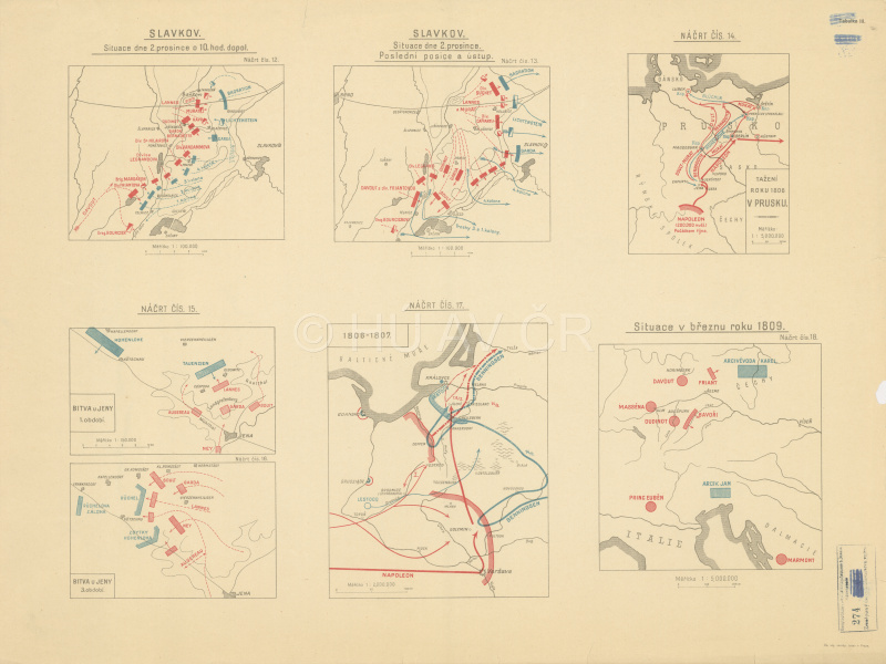
Cartographic illustration of the Napoleonic Wars on seven plans, produced by the Military Geographical Institute (after 1918). Map Collection of the Institute of History, CAS. Display map
References
Kotulán, J. – Uhlíř, D. (eds.) Evropa 1805. Brno 2006;
Raková, S. – Lequesne, Ch. (eds.): Jakou Evropu ohlašovala bitva u Slavkova? Praha 2006;
Pod císařským praporem. Historie habsburské armády 1526–1918. Praha 2003;
Bělina, P. – Fučík, J. Válka 1866. Praha – Litomyšl 2005;
Semotanová, E. ‒ Cajthaml, J. a kol.: Akademický atlas českých dějin. Praha 2014, 2. akt. vydání 2016.

This work is licensed under a Creative Commons BY-NC-ND 4.0
The Czech Lands and the Napoleonic Wars
Transformations following the French Revolution (1789) soon presented a danger to the rest of Europe. The Napoleonic Wars did not evade the Czech Lands whose population faced war requisitions, taxes and payments to the army. In 1805, the Battle of Austerlitz, also known as the Battle of the Three Emperors, became the decisive encounter in the War of the Third Coalition and also Napoleon's greatest triumph. The Czech Lands last became witness to the fights in 1813 (in the Battle of Priesten, Battle of Kulm and Battle of Arbesau), which, however, were of a lower strategic significance.
Cartographic illustration of the Napoleonic Wars on seven plans, produced by the Military Geographical Institute (after 1918). Map Collection of the Institute of History, CAS. Display map
References
Kotulán, J. – Uhlíř, D. (eds.) Evropa 1805. Brno 2006;
Raková, S. – Lequesne, Ch. (eds.): Jakou Evropu ohlašovala bitva u Slavkova? Praha 2006;
Pod císařským praporem. Historie habsburské armády 1526–1918. Praha 2003;
Bělina, P. – Fučík, J. Válka 1866. Praha – Litomyšl 2005;
Semotanová, E. ‒ Cajthaml, J. a kol.: Akademický atlas českých dějin. Praha 2014, 2. akt. vydání 2016.
This work is licensed under a Creative Commons BY-NC-ND 4.0
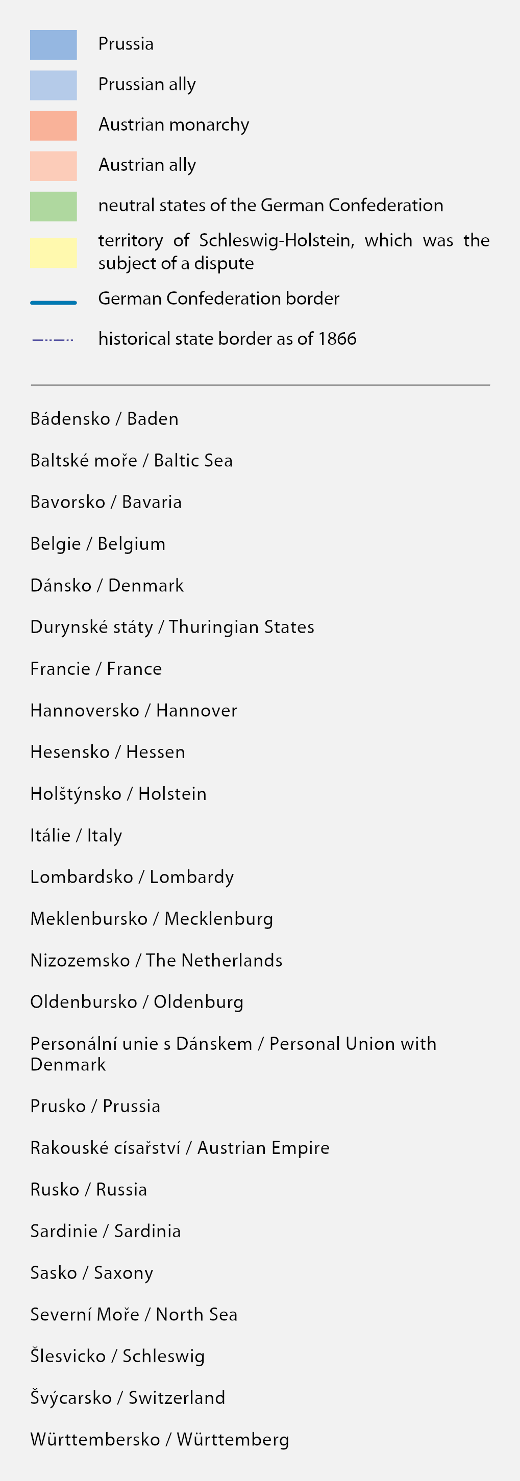
Military operations of 1866 and the Battle of Königgrätz
The disputes between Austria and Prussia concerned the division and administration of a territory seized after the Second Schleswig War (1864) and issues connected with the unification of Germany. Prussia wanted to enforce unification under its own command and exclude Austria, which finally happened. In the decisive Battle of Königgrätz (1866), the Austrian army suffered a catastrophic defeat. After occupying Prague, the Prussian army advanced as far as Mikulov where a provisional peace was agreed, thus preventing occupation of the Habsburg metropolis.
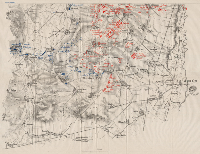
Contemporary plan of the Battle of Königgrätz, 3 July 1866. Map Collection of the Institute of History, CAS. Display map
References
Pod císařským praporem. Historie habsburské armády 1526–1918. Praha 2003;
Bělina, P. – Fučík, J. Válka 1866. Praha – Litomyšl, 2005;
Kotulán, J. – Uhlíř, D. (eds.) Evropa 1805. Brno 2006;
Raková, S. – Lequesne, Ch. (eds.): Jakou Evropu ohlašovala bitva u Slavkova? Praha 2006;
Semotanová, E. ‒ Cajthaml, J. a kol.: Akademický atlas českých dějin. Praha 2014, 2. akt. vydání 2016.
This work is licensed under a Creative Commons BY-NC-ND 4.0
Military operations of 1866 and the Battle of Königgrätz
The disputes between Austria and Prussia concerned the division and administration of a territory seized after the Second Schleswig War (1864) and issues connected with the unification of Germany. Prussia wanted to enforce unification under its own command and exclude Austria, which finally happened. In the decisive Battle of Königgrätz (1866), the Austrian army suffered a catastrophic defeat. After occupying Prague, the Prussian army advanced as far as Mikulov where a provisional peace was agreed, thus preventing occupation of the Habsburg metropolis.
Contemporary plan of the Battle of Königgrätz, 3 July 1866. Map Collection of the Institute of History, CAS. Display map
References
Pod císařským praporem. Historie habsburské armády 1526–1918. Praha 2003;
Bělina, P. – Fučík, J. Válka 1866. Praha – Litomyšl, 2005;
Kotulán, J. – Uhlíř, D. (eds.) Evropa 1805. Brno 2006;
Raková, S. – Lequesne, Ch. (eds.): Jakou Evropu ohlašovala bitva u Slavkova? Praha 2006;
Semotanová, E. ‒ Cajthaml, J. a kol.: Akademický atlas českých dějin. Praha 2014, 2. akt. vydání 2016.
This work is licensed under a Creative Commons BY-NC-ND 4.0
War conflicts and their consequences
The military and the maps make a significant “alliance” in particular during the wars – in preparations to their strategically long-term objectives and the overall idea of the planned military operations and in the use of tactical methods in each war. This is because the simplified map illustrations of the attacked (but also defended) ground represent navigation aids, which point at the relations between its objects. This situation often heavily affected the war logistics and thus the final outcome. From the 15th century to the 20th century, this “alliance” experienced a huge development as regards the form and contents. The outcome is the understanding that for the military “clash of the wills” presented as interaction between two or more military forces, maps of various types (i.e. military topographic maps of various types and special focus, specific maps, the so-called atypical maps such as planimetric maps, aerial maps, photo mosaics or map graphics of joint air-ground operations) are extremely important. Cooperation between historians, geographers and cartographers (and thus the history, historical geography, interdisciplinary historiography exploring transformations of geographic space in the time, historical cartography, interdisciplinary disciplines dealing with the processing of historical events and processes on the maps) has always been important for the development of military maps per se, but also for the understanding of the facts and contexts of the wars and their consequences as the permanent components of the human history, mainly in the form of reconstruction maps such as the Wars and their Consequences, which are the results collective sets of findings on wars against the Hussites, battles of the Thirty Year War and wars for the Austrian and Bavarian heritage on the Czech territory. Similarly, a complex view of the complicated 20th century burdened with the wars is presented, based on detailed analytic probes into complicated and hitherto unprocessed themes of the First World War and Second World War (e.g. the POW camps).
Zlatica Zudová-Lešková
Subchapters:
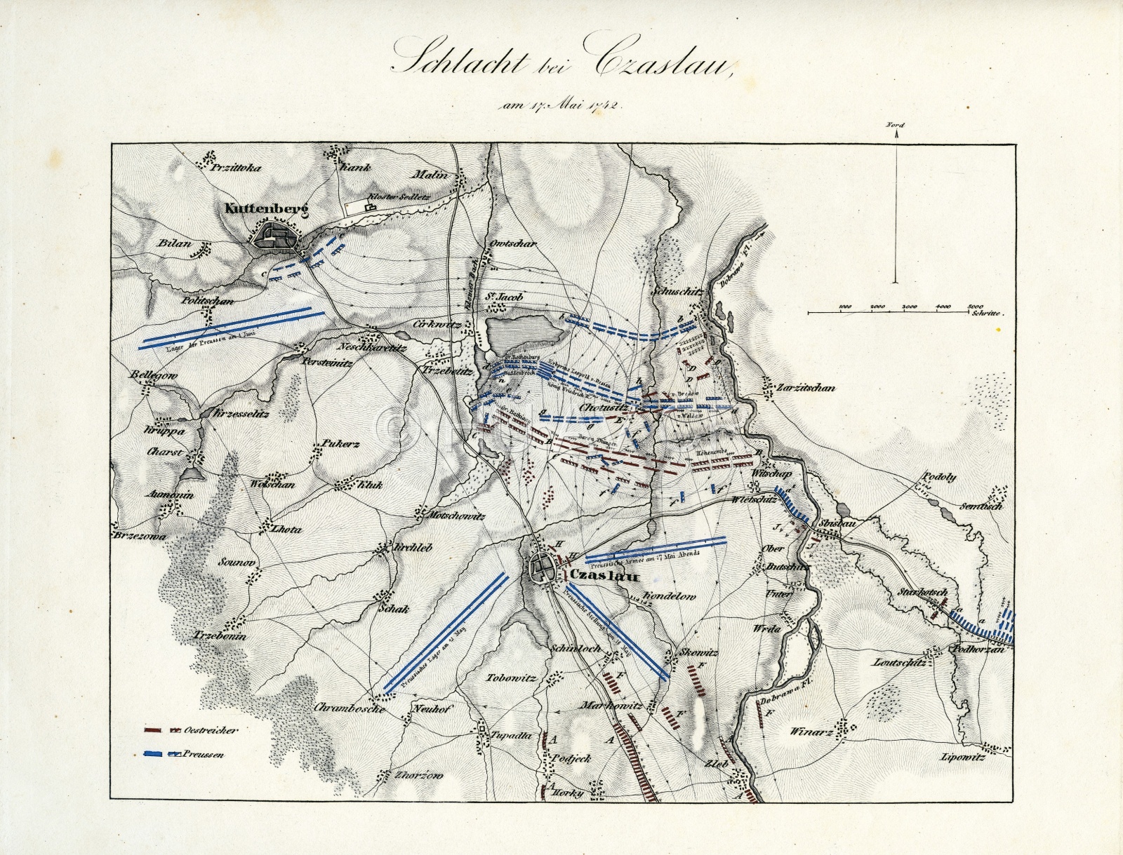
Contemporary plan of the Battle of Čáslav on May 17, 1742. Map collection of the Institute of History, CAS. Map display
Authors
historians: Zlatica Zudová-Lešková, Daniela Králíková, Pavel Kůrka, Jiří Mikulec, Jitka Močičková, Miloslav Polívka, Petr Prokš, Eva Semotanová, Aleš Vyskočil
cartographers: Tomáš Janata, Jiří Cajthaml, Pavel Seemann, Petr Soukup, Růžena Zimová
digital atlas: Tomáš Janata, Petra Jílková, Jiří Krejčí, Jitka Močičková, Eva Semotanová, Růžena Zimová
team of authors
References
Clausewitz, C. von: On War. Princeton 1976;
Heřtová, Y.: Zákopová válka. Praha 2008;
Hrbek, J. – Smetana, V. a kol.: Draze zaplacená svoboda: Osvobození Československa 1944–1945. Praha 2009;
Sutor, B.: Od spravedlivé války k spravedlivému míru?. Praha 2014;
Semotanová, E. Zudová-Lešková, Z. ‒ Močičková, J. Cajthaml, J. ‒ Seemann, P. ‒ Bláha J. D. a kol.: Český historický atlas. Kapitoly z dějin 20. století. Praha 2019.
Czech State and Europe in the 20th Century
Historical Milestones, Periods and Consequences