Territorial development of Czechoslovakia in 1918‒1924
The shape of the Czechoslovak borders and territories was legally anchored by a series of peace treaties – the Treaty of Versailles that emerged from the Paris Peace Conference in 1919–1920.The individual treaties, which concerned the demarcation of the Czechoslovak borders, were signed with Germany in Versailles, with Austria in Saint-Germain-en-Laye and with Hungary in Trianon. The basic requirements of Czechoslovakia regarding the recognition of its state borders had been proposed by Tomáš Garrigue Masaryk already during the First World War. The actual border adjustments proceeded until 1924.
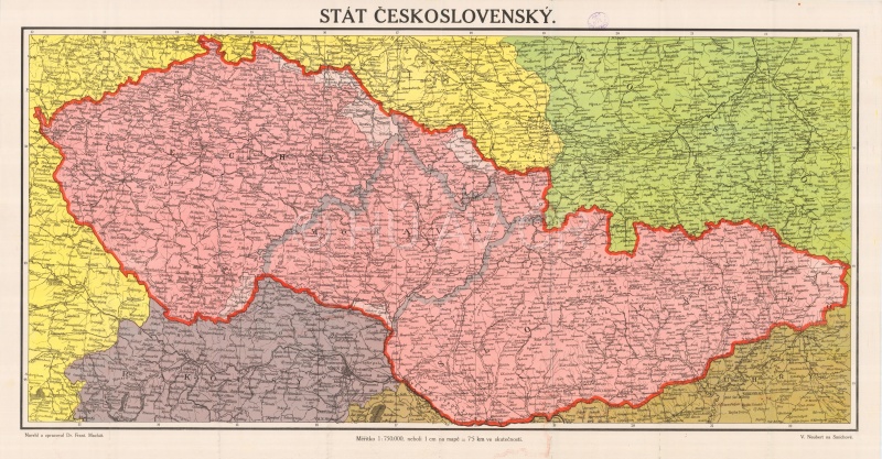
Map of Czechoslovakia from 1918/1919, private collection of Tomáš Grim Display map
References
Dejmek, J. a kol.: Československo. Dějiny státu. Praha 2018;
Semotanová, E. Zudová-Lešková, Z. ‒ Močičková, J. Cajthaml, J. ‒ Seemann, P. ‒ Bláha J. D. a kol.: Český historický atlas. Kapitoly z dějin 20. století. Praha 2019;
Martínek, J.: Co všechno bude naše? Názory českých geografů na vymezení hranic v letech 1918 – 1920, in: Hranice v krajinách (Semotanová, E. ed.). Praha 2020.

This work is licensed under a Creative Commons BY-NC-ND 4.0
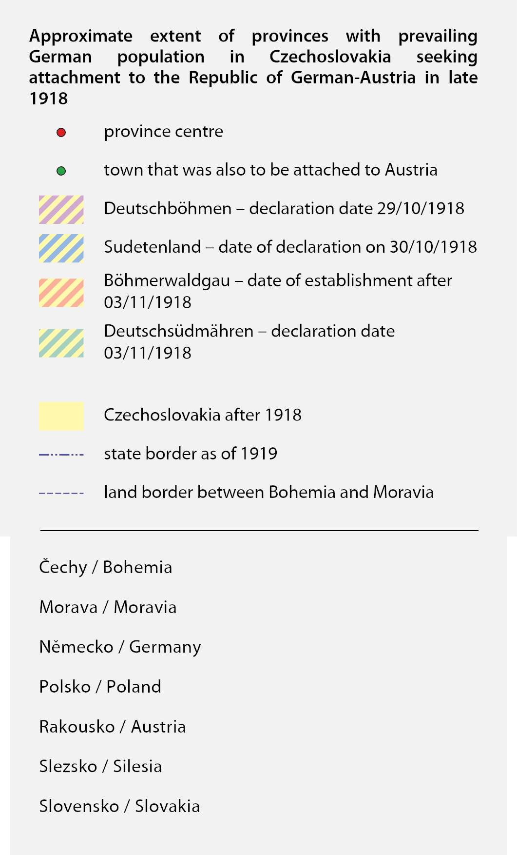
Development of border provinces with predominance of German population in Czechoslovakia
On 21 October 1918, the independent state of German Austria, Deustch-Österreich was declared in Vienna. In addition to the Austrian lands, it was to include the border areas of Bohemia, Moravia and Silesia. After the establishment of independent Czechoslovakia on 28 October 1918, representatives of the Sudeten Germans declared four separatist provinces. The independent enclaves were to include the towns of Brno, Jihlava and Olomouc. The Czechoslovak government suppressed these separatist attempts with the use of the army.
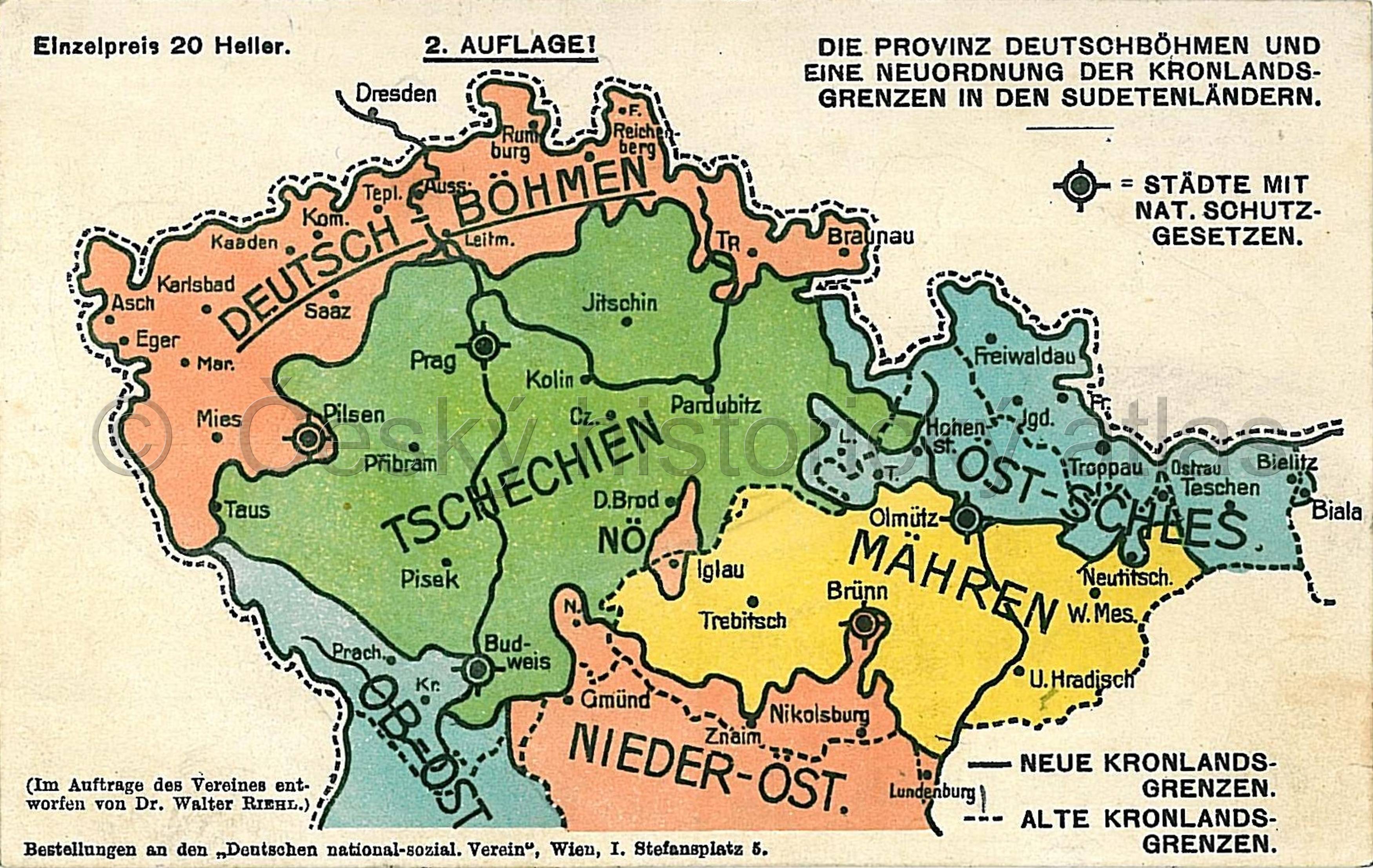
Map of border provinces from 1918, private collection of Tomáš Grim
References
Scheuch, M.: Historischer Atlas Österreich. Wien 2008, on-line, dostupné z https://austria-forum.org/web-books/historischeratl00de2008tub/00000215 [ověřeno 20. 1. 2020];
Dejmek, J. a kol.: Československo. Dějiny státu. Praha 2018;
Semotanová, E. Zudová-Lešková, Z. ‒ Močičková, J. Cajthaml, J. ‒ Seemann, P. ‒ Bláha J. D. a kol.: Český historický atlas. Kapitoly z dějin 20. století. Praha 2019.
This work is licensed under a Creative Commons BY-NC-ND 4.0
Territorial development of Czechoslovakia following the Munich Agreement and the Vienna Award
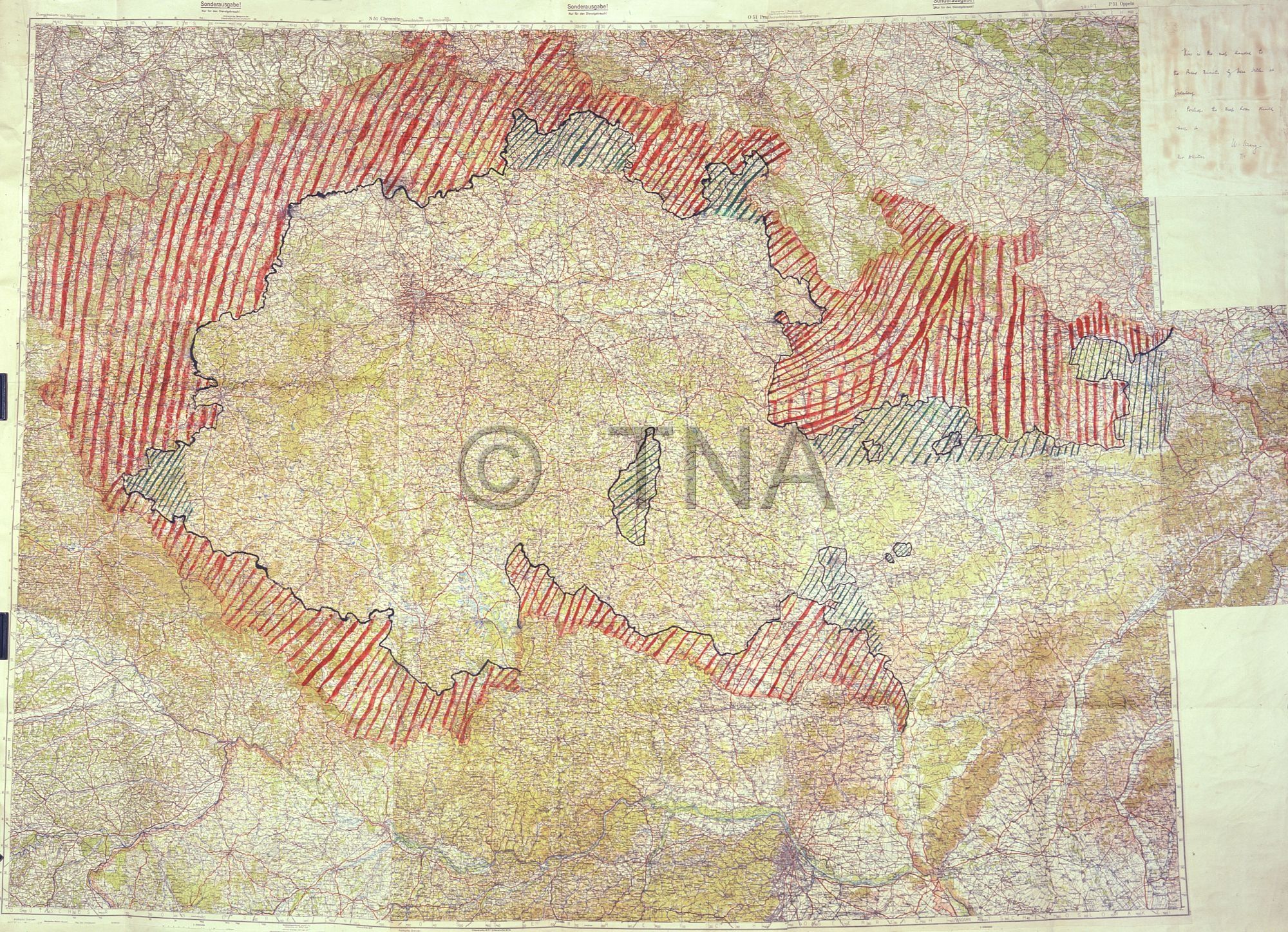
The Munich Agreement of 29 September 1938 entailed significant territorial losses for Czechoslovakia and violation of its territorial integrity. From 1 to 10 October 1938, German troops annexed four territorial zones defined by the great powers in Bohemia and Moravia including Petržalka in Bratislava. The fifth zone was set out by an international committee of signatories to the Munich Agreement at a meeting in Berlin in October 1938.Poland and Hungary also enforced their claims on parts of Czechoslovakia. Territories seized from Czechoslovakia represented about 38 % of its original area and 36 % of the population of Bohemia and Moravia.
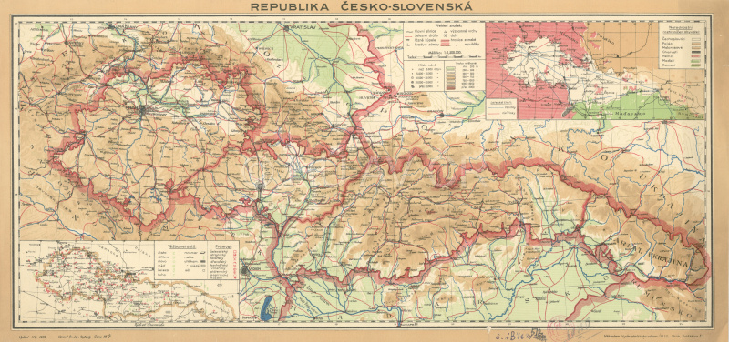
Map of the Czecho-Slovak Republic from 1938. Map Collection of the Institute of History, CAS. Display map
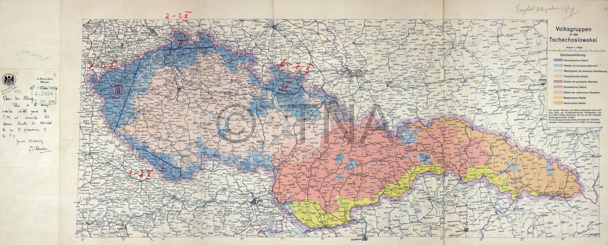
Map with drawn German territorial claims against Czechoslovakia, which A. Hitler handed over to N. Chamberlain on September 24, 1938 in Godesberg. The National Archives, London, fond Foreign Office 925 (Maps and Plans), 20107.
Map with four zones of Czechoslovak territory ceded to Germany, which A. Hitler handed over to N. Chamberlain at a meeting in Munich and which forms an annex to the Munich Agreement of September 30, 1938. The National Archives, London, Foreign Office 925 (Maps and Plans), 20108.
References
Kuklík, J. – Němeček, J. – Šebek, J.: Dlouhé stíny Mnichova. Mnichovská dohoda očima signatářů a její dopady na Československo. Praha 2011;
Faber, D.: Mnichov: krize appeasementu 1938. Praha 2015;
Semotanová, E. Zudová-Lešková, Z. ‒ Močičková, J. Cajthaml, J. ‒ Seemann, P. ‒ Bláha J. D. a kol.: Český historický atlas. Kapitoly z dějin 20. století. Praha 2019.
This work is licensed under a Creative Commons BY-NC-ND 4.0
Territorial development of former Czechoslovakia since 14 March 1939
The existence of post-Munich Czecho-Slovakia was terminated by the establishment of the separate Slovak State on 14 March 1939 and Nazi occupation of the Czech lands on 15 March 1939.After the defeat of Poland in September 1939, the German Reich also gained Cieszyn Silesia, which had been annexed by Poland and Germany thus occupied the entire territory of Bohemia, Moravia and Silesia. Hungary occupied the east parts of the Slovak State on 23 March 1939.Conversely, in September 1939, Slovakia gained border areas of the Polish territory annexed by Poland in 1920, 1924 and 1938 as a result of German goodwill.
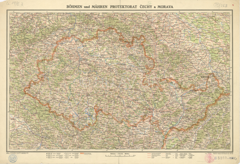
Map of the Protectorate of Bohemia and Moravia from 1942. Map Collection of the Institute of History, CAS. Display map
References
Gebhart, J. ‒ Kuklík, J.: Dramatické i všední dny Protektorátu. Praha 1996;
Kuklík, J. – Němeček, J. – Šebek, J.: Dlouhé stíny Mnichova. Mnichovská dohoda očima signatářů a její dopady na Československo. Praha 2011;
Semotanová, E. Zudová-Lešková, Z. ‒ Močičková, J. Cajthaml, J. ‒ Seemann, P. ‒ Bláha J. D. a kol.: Český historický atlas. Kapitoly z dějin 20. století. Praha 2019.
This work is licensed under a Creative Commons BY-NC-ND 4.0
Czechoslovakia within the post-1945 borders. The Czech Republic within the post-1992 borders
In 1945, Czechoslovakia was restored within borders valid on 30 September 1938.After the Second World War, Subcarpathian Ruthenia became part of the Ukrainian Soviet Socialist Republic under a treaty between Czechoslovakia and the Soviet Union of 29 June 1945.In 1947, Czechoslovakia gained three villages from Hungary on the right bank of the Danube – Jarovce, Rusovce, Čunovo and part of the Rajka region (today part of Bratislava).In the period from 1947 until 1992, there were no significant changes of the state borders. The establishment of the Czech Republic and the Slovak Republic on 1 January 1993 brought about minor border adjustments, most recently in 1997. These involved parts of the village of Sidonie (the territory passed to the Czech Republic) and U Sabotov (to the Slovak Republic).
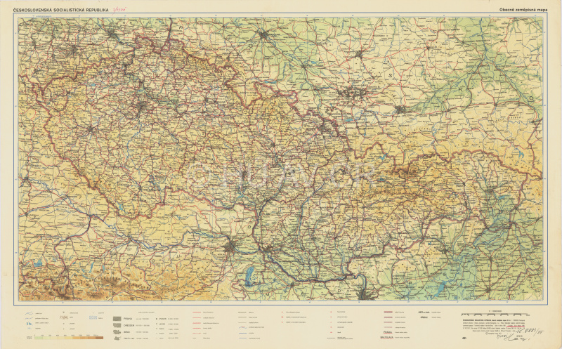
Map of Czechoslovakia from 1981. Map Collection of the Institute of History, CAS. Display map
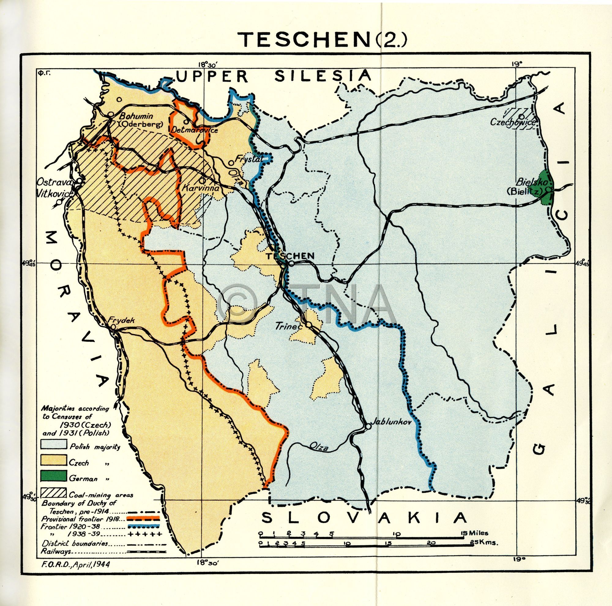
Map of the Těšín region, attached to the memorandum Research Department Foreign Office, The Polish-German and Polish-Czechoslovak Frontiers of March 27, 1944, relating to border issues (Annex V: The Teschen Question). National Archives, fond Foreign Office 404, Confidential Prints 1944, 30/3.
References
Šmída, Z.: Vývoj českých státních hranic. Praha 2016;
Burda, T. Semotanová. E. Chromý, P. a kol.: 100 let proměn hranic našich regionů. Libreto k výstavě. Praha 2018 on-line, dostupné z https://www.mvcr.cz/clanek/100-let-promen-hranic-nasich-regionu.aspx [ověřeno 20. 1. 2020];
Semotanová, E. Zudová-Lešková, Z. ‒ Močičková, J. Cajthaml, J. ‒ Seemann, P. ‒ Bláha J. D. a kol.: Český historický atlas. Kapitoly z dějin 20. století. Praha 2019.
This work is licensed under a Creative Commons BY-NC-ND 4.0