Urbanization of the Czech Lands in the 19th and early 20th centuries
Urbanization of the European landscape is part of the overall transformation of the society affected by the development of industry, agriculture, and transport. The number of inhabitants in towns rapidly increased and rural areas tied to large cities changed when the urban built-up areas gradually expanded. The Czech Lands were hit by this process around the year 1830, but especially in the second half of the 19th century and early 20th century. The residential system started to separate into two parts – northern and southern, with different dynamics of development. The southern, mostly farming areas of the Czech Lands were not heavily affected by the process of urbanization. However, important industrial sectors (mining of minerals, mechanical engineering, metallurgy, textile industry, etc.) concentrated in Prague, Brno, north-west and north Bohemia, north Moravia and Czech Silesia.
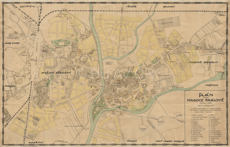
Plan of Hradec Králové, about 1900. Map Collection of the Institute of History, CAS. Display map
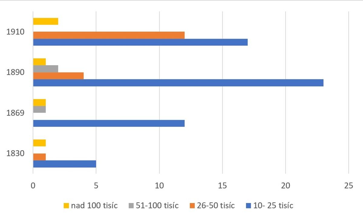
Development of the number of cities in selected size categories. Source: ČSU
References
Aut. kol.: Historický atlas měst České republiky, sv. 1-31. Praha 1995‒2020;
Horská, P. - Maur, E. – Musil, J.: Zrod velkoměsta. Urbanizace českých zemí a Evropa. Praha – Litomyšl 2002;
Semotanová, E. ‒ Cajthaml, J. a kol.: Akademický atlas českých dějin. Praha 2014, 2. akt. vydání 2016.

This work is licensed under a Creative Commons BY-NC-ND 4.0
Urbanization of the Czech Lands in the 20th century
In the 20th century, the worldwide trend continued in the emergence of metropolises as large urban agglomerations with many millions of inhabitants. The influx of people to the cities also increased in the Czech Lands where large urbanized areas emerged and the social composition of the cities, their interior spaces, the environs, and finally the entire residential structure transformed. The importance of towns as catchment centres was growing together with the expansion of the administrative, educational and cultural functions, economic and transport transformations of the town and its surroundings as well as the new urban projects. In the second half of the 20th century, large urbanised areas developed around large industrial centres – Prague, Plzeň and Brno, north-west Bohemia, Liberec, Hradec Králové, Pardubice, Olomouc and Ostrava and in Slovakia around Bratislava, Trnava, Nitra, Košice, and Prešov. The population in less populated and smaller towns thickened and created belts of the urbanized landscape. Intensive populating of the new type of suburban landscape (suburbanisation process) started in the 1990s. Logistic centres and new commercial and industrial zones gradually emerged alongside the residential complexes (satellite towns). In large towns, inner urban peripheries in place of the vanished industrial zones were transformed into commercial, residential, and recreational complexes.
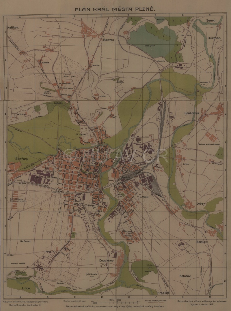
Plan of Plzeň (1912). Map Collection of the Institute of History, CAS. Display map
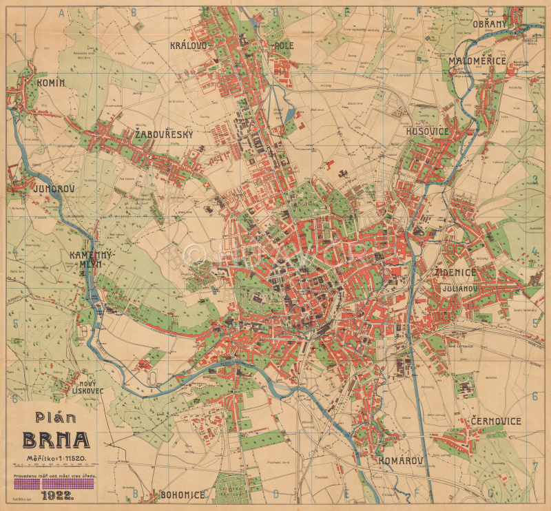
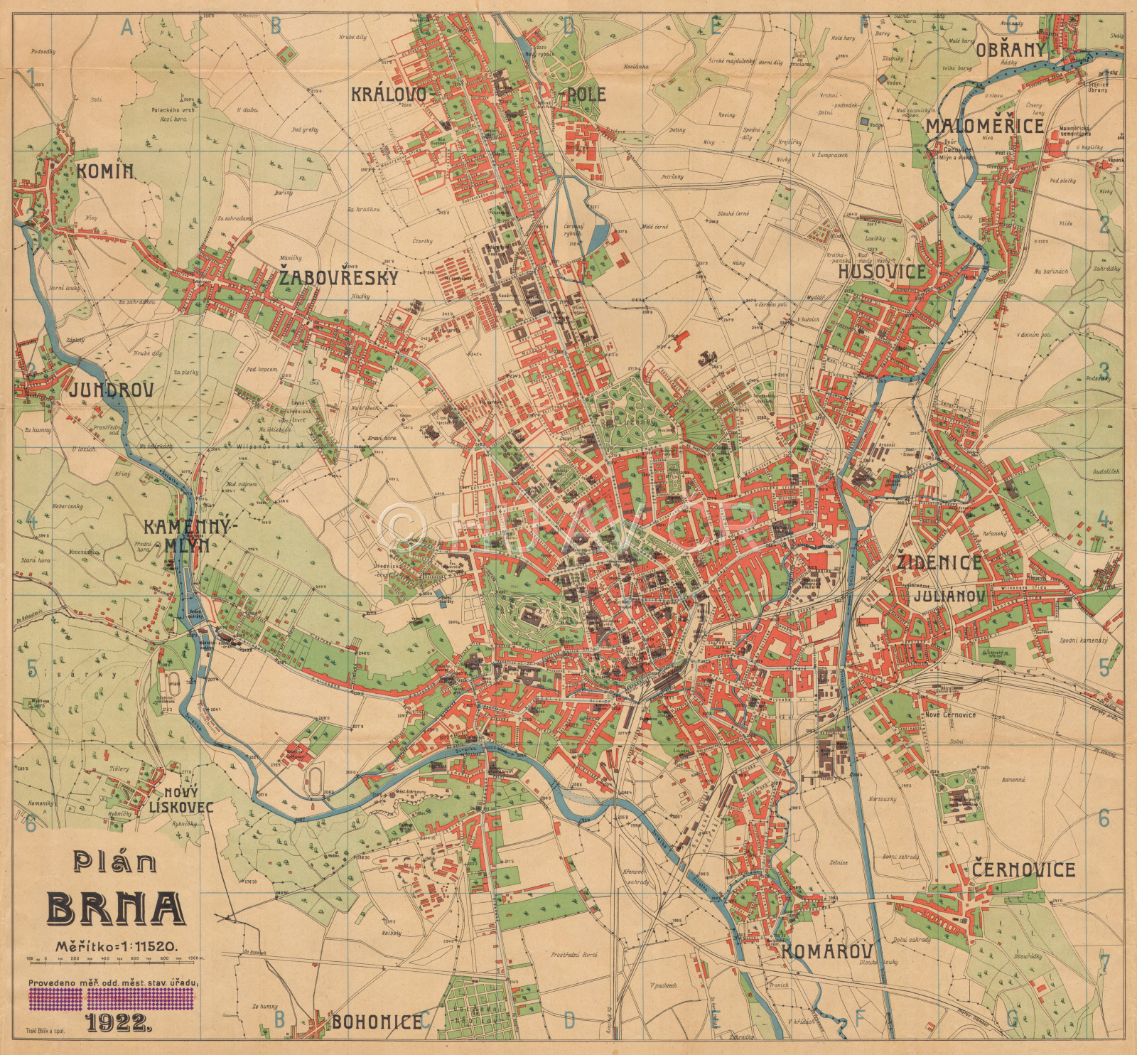
Plan of Brno (1922). Map Collection of the Institute of History, CAS. Display map
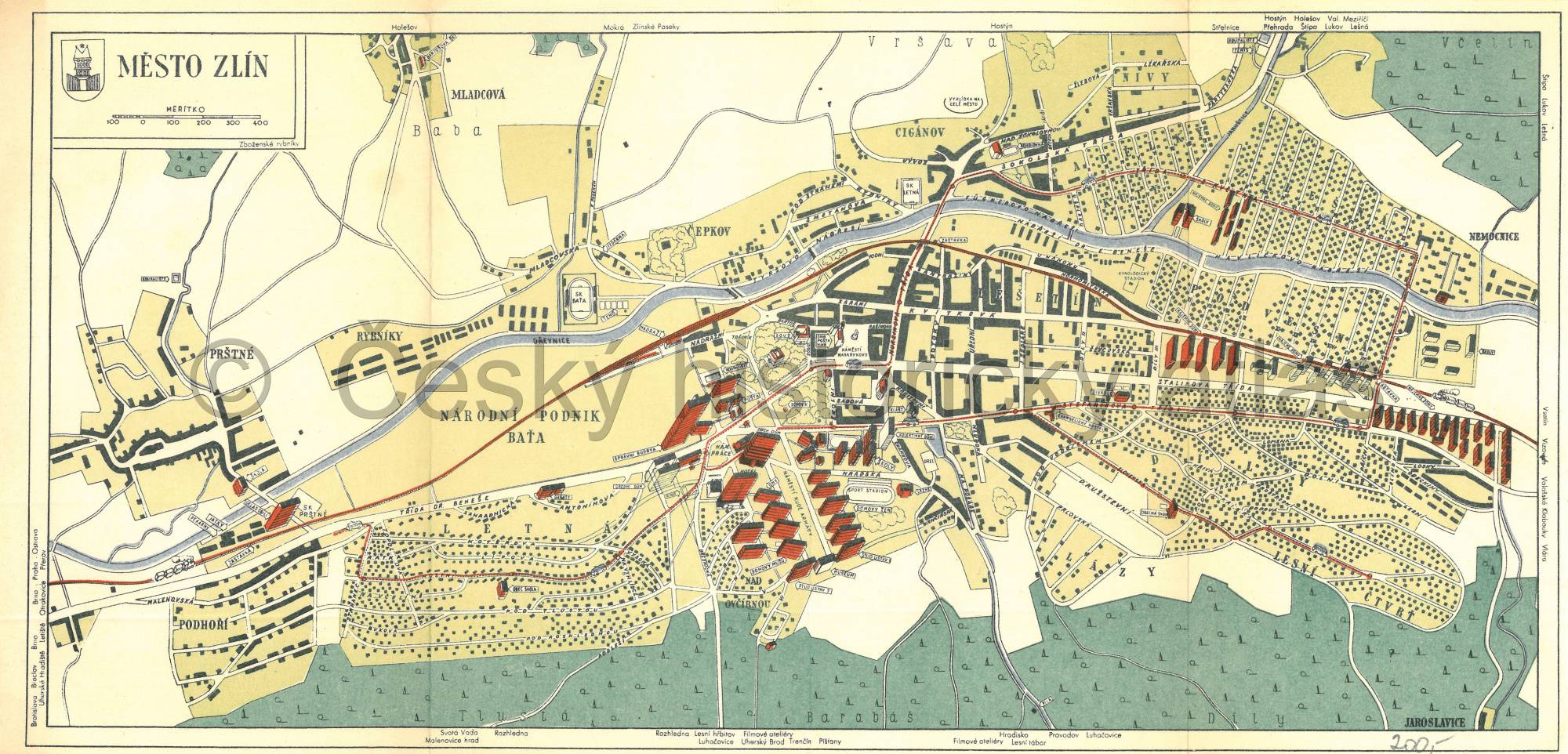
Plan of Zlín (1945–1948). Private collection of Günter Fiedler
References
Aut. kol.: Historický atlas měst České republiky, sv. 1-31, srov. Mapový portál Historického atlasu měst ČR, dostupné z http://towns.hiu.cas.cz/ [ověřeno 5. 2. 2020];
Horská, P. - Maur, E. – Musil, J.: Zrod velkoměsta. Urbanizace českých zemí a Evropa. Praha – Litomyšl 2002;
Hnilička, P.: Sídelní kaše. Praha 2005;
Semotanová, E. ‒ Cajthaml, J. a kol.: Akademický atlas českých dějin. Praha 2014, 2. akt. vydání 2016.
This work is licensed under a Creative Commons BY-NC-ND 4.0
Urbanization of the Czech Lands at the beginning of the 21st century
In the 20th century, the worldwide trend continued in the emergence of metropolises as large urban agglomerations with many millions of inhabitants. The influx of people to the cities also increased in the Czech Lands where large urbanized areas emerged and the social composition of the cities, their interior spaces, the environs, and finally the entire residential structure transformed. The importance of towns as catchment centres was growing together with the expansion of the administrative, educational and cultural functions, economic and transport transformations of the town and its surroundings as well as the new urban projects. In the second half of the 20th century, large urbanised areas developed around large industrial centres – Prague, Plzeň and Brno, north-west Bohemia, Liberec, Hradec Králové, Pardubice, Olomouc and Ostrava and in Slovakia around Bratislava, Trnava, Nitra, Košice, and Prešov. The population in less populated and smaller towns thickened and created belts of the urbanized landscape. Intensive populating of the new type of suburban landscape (suburbanisation process) started in the 1990s. Logistic centres and new commercial and industrial zones gradually emerged alongside the residential complexes (satellite towns). In large towns, inner urban peripheries in place of the vanished industrial zones were transformed into commercial, residential, and recreational complexes.
Aerial view of Most. Photo Pavel Vychodil, 2008.
References
Aut. kol.: Historický atlas měst České republiky, sv. 1-31, srov. Mapový portál Historického atlasu měst ČR, dostupné z http://towns.hiu.cas.cz/ [ověřeno 5. 2. 2020];
Horská, P. - Maur, E. – Musil, J.: Zrod velkoměsta. Urbanizace českých zemí a Evropa. Praha – Litomyšl 2002;
Hnilička, P.: Sídelní kaše. Praha 2005;
Semotanová, E. ‒ Cajthaml, J. a kol.: Akademický atlas českých dějin. Praha 2014, 2. akt. vydání 2016.
This work is licensed under a Creative Commons BY-NC-ND 4.0
Towns as centres of the main territorial administrative units since 1918
Towns became centres of the emerging territorial and administrative units as the historical regions in the Czech Lands. Some of them have kept their position of an administrative centre for centuries, others only throughout the validity of the particular administrative reform. The traditions and consistency of some locations as territorial administrative centres go deep into the 15th century (Plzeň, Hradec Králové) and the 16th century (Brno and Jihlava). Prague, or the four towns of Prague until 1784, has always been a special administrative unit as the capital city of the Czech state.
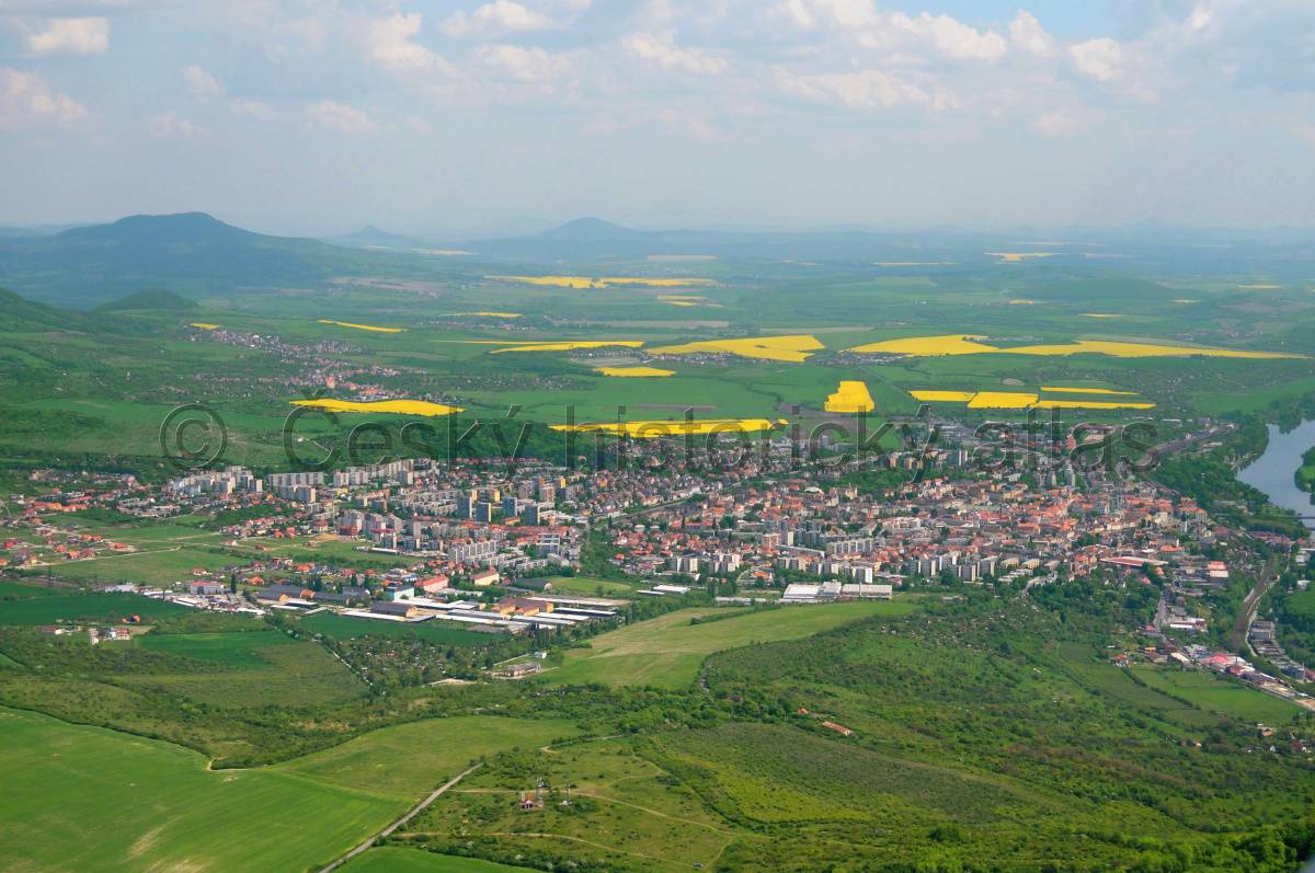
Aerial view of Litoměřice, till 2002 county seat. Photo Pavel Vychodil, 2008.
References
Aut. kol.: Historický atlas měst České republiky, sv. 1-31, srov. Mapový portál Historického atlasu měst ČR, dostupné z http://towns.hiu.cas.cz/ [ověřeno 5. 2. 2020];
Burda, T.: Význam změn správních hranic v procesu formování vnitřních periferií na území Česka od poloviny 19. století. Netištěná dizertační práce ‒ PřF, KSGRR, UK. Praha 2014;
Semotanová, E. ‒ Zudová-Lešková, Z. ‒ Močičková, J. Cajthaml, J. ‒ Seemann, P. ‒ Bláha J. D. a kol.: Český historický atlas. Kapitoly z dějin 20. století. Praha 2019.
This work is licensed under a Creative Commons BY-NC-ND 4.0